Oh baby, it’s a wanderful life – Part V // Bad Leonfelden

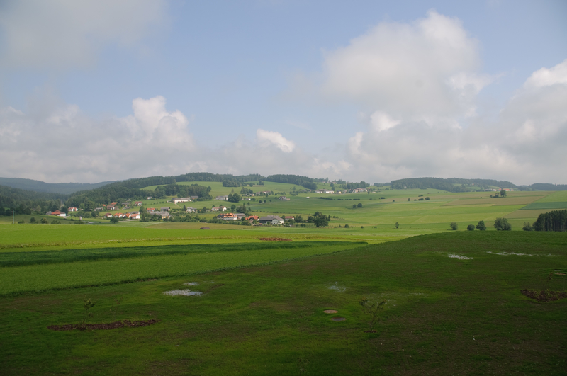
The fifth part of our hiking series “Oh Baby, it’s a wanderful life” takes us to the picturesque Mühlviertel. Unspoiled river valleys, green meadows, and rolling hills: The Mühlviertel, the Upper Austrian region between the Danube in the south and the Bohemian Forest in the north, is surrounded by varied landscapes. Whether steep, challenging mountain tours or flat & leisurely walking trails – everyone will find the right hiking tour for them here. No matter what you decide, one thing is clear: those who lace up their hiking boots in the Mühlviertel are embarking on an unforgettable journey of discovery.

1 // Moorland forest experience trail

The adventure trail Moorwald is a leisurely adventure trail that provides interesting insights into the mystery of the “Moorwald”. Awarded the Environmental Prize 2003 of the Province of Upper Austria, the adventure hiking trail offers an instructive pleasure that brings you closer to the habitats of forest and moor in an eventful way. The hiking trail starts at the town square of Bad Leonfelden. As soon as you have discovered the signpost, a small wooden oak cat, you can start. The 6-kilometer-long route takes you through dense forests, extensive moor landscapes, and unspoiled nature.
First, you pass the Rubenerteich and then hike north through a dense spruce forest. Then you go up to the mighty granite peaks, the “Lehrmüller wall”. From here you can enjoy a unique view over the wide hilly country and if you are lucky, you can also catch a glimpse of the Alps.
© Kurverband Bad Leonfelden
Tip: the moor water! In summer, the pure moor water invites you to refresh yourself after the hike. But you can also treat yourself to a refreshing moor foot bath. This is said to have a healing effect on health. Then continue to the high moor. Once there, you will certainly notice a high stand in the middle of the moor, from which you can overlook the entire moor. Through the high forest, the path leads back to the Rubenerteich, and from there to the starting point of the hike.
Tourfacts: easy // 6 km // 158 hm// 2:00 h

2 // The Sternstein: A mountain with a view

The hiking route to the 1120 meter high Sternstein is a bit more challenging. On this 16-kilometer circular hiking trail, nature enjoyment, scenic highlights and culinary delights await you along the way.
© OÖ.Tourismus/Röbl
We start at the Mühlviertler valley station. From here you walk about 200 m back along the asphalt road and then about 100 meters uphill. Mostly you hike on forest roads until you are just before the summit. Then you hike a short piece uphill, just follow the red stickers with the inscription “Sternstein-Runde”.
© OÖ.Tourismus/Röbl
Treat yourself to a short detour to the Waldschenke mountain inn, the culinary highlight along the way. From the parking lot of the Waldschenke, you hike to the summit of the Sternstein and the 20m high lookout point, where you can enjoy a unique view of the Mühlviertel hills. Afterwards you go eastwards on the forest road over the “1000m Platzl” back to the starting point. Tip: At the signpost “Rading” a short detour to the so-called “mushroom stone” is worthwhile. This idiosyncratic stone shape is a freak of nature and has been a natural monument since 1980.
Tourfacts: moderate // 16 km// 360 hm // 4:00 h
© Mühlviertel Marken GmbH/Erber

3 // Between the Danube and the Vltava: a historical border hike.

The cross-border Salzsstraßen-Runde is 35 kilometers long and leads from Bad Leonfelden to the Czech Republic bordering to the north. On the former trade route between the rivers Vltava and Danube you will embark on a historically interesting discovery tour. You start at the town square of Bad Leonfelden. The blue marking “Salzstraße-Runde” leads you on forest paths over the border crossing Rading to the Czech Hohenfurt. Definitely worth seeing highlights on the circular route are the Swedish redoubt from the 30-year war and the remains of the village of Reifmas. You will also pass the European watershed and reach the southernmost point of the Bohemian Forest. You will find refreshments on the way to the Jarding snack station. Here you can enjoy regional delicacies!
Tourfacts: medium difficult // 35 kilometers // 750 hm // 10:00 h
Whether circular and themed hikes for a short excursion or larger long-distance and stage trails: the Mühlviertler Hügelland allows deep insights into the region, its culture and special features. Here, every hiking enthusiast will find the perfect route for him or her! On a hill in the middle of the Mühlviertel landscape, lies the source of inner harmony, nature, and enjoyment, the Falkensteiner Hotel & Spa Bad Leonfelden. From the hotel, active vacationers can quickly reach various hiking trails or explore the dreamlike nature of the Mühlviertel on e-bikes and Segways.

Tauche ein und finde...

Dive in and find...